Extra Pages

Monday, October 17, 2011

It's All Over Now Baby Blue

It has been an interesting experiment. In the last year I have shared my love of music, the outdoors and my faith in Jesus. And even shared some of my old artwork, and my feelings as I went through the loss of my father. But the experiment has to come to an end. The blog while a release for my creative expression has taken time away from me being the father, husband, and leader of my home. So it is time I practice what I preach and prioritize my time for the more important things. I will leave the blog up so the music and other things will still be available. At the end there was an average of 8 or 9 visitors at every moment during the day and people coming from around the world to the tune of a couple of thousand a day.
Over the last year there have been many events but the loss of my father stands out for me. Thanks to all who prayed for my father, my mom and my family during that tough time. When people pass away we are reminded of the grim fact that we all are going to eventually come to an end. That realization can leave us with a hopelessness and emptiness when we realize there is no true lasting value in much of the things we work for.

 If I could leave you with one last thought it would be that though there is despair and hopelessness in death, there is a place to find hope. It is the fact that 2000 years ago a man made a promise. He predicted that He would be put to death and put in a tomb, but he would return to life in three days as a sign to us all. Jesus did just that and it shook up the world and is still shaking up the world today. And in that kept promise He lead the way for us all to defeat death too. Because He made another promise that those who believe in Him and choose to place Him as Lord in their lives shall also be resurrected and have everlasting life.
    What will that look like? Well when Jesus came back we saw that relationships still mattered in fact he asked Peter three times "Do you love Me?" In the end that's what it may be all about.  Relationships and how we impacted others may be about all there is that is lasting of these short lives we live.
Being a follower does not come with a promise of an easy life. In fact it comes with trials and hardship and suffering, but in being a follower there will be purpose and meaning found in our difficult times. And those things will be used and turned to good to grow us and change us and shape us into something better. Hopefully we get changed into someone who is better at this relationship thing, because we will be together for eternity we will need to be good at it I guess.
     If you are on standby for a flight wondering if you are going to get on the flight it can be very unsettling, but once you have that boarding pass in hand you can rest and relax. Well I'm happy to say I have my boarding pass for that "final flight" and I can take rest in that realization. But for those who don't isn't it time to get it in order, because this is one flight we just never know when it departs.  Could be tomorrow!
Adios and Happy Trails!
Thanks for all who came here and I hope there has been some value in this little experiment.
Bless Ya!   from Arizona Jones

All Over Now Baby Blue

Sunday, October 16, 2011

Grateful Dead, The Frost, 10-10-1982 (SBD)

This is the last music I will be posting. So I decided to give you one of my old favorites. This Grateful Dead show has special feel to it. The second set just flows from song to song. And the set list is great. This is some of the earliest examples of Throwing Stones and Touch Of Grey. If fact this is the first time the band linked Throwing Stones to Not Fade Away, something that would be a part of set lists for years after this. Crazy Fingers had only been brought back into the rotation earlier in the summer making it special for the Bay Area fans. All the songs are played well and it ends with a great double encore of the Rolling Stones song Satisfaction and then It's All Over Baby Blue. And it is all over sorry to say. Thanks for being a part of it.

Grateful Dead
Stanford University
Frost Amphitheatre
Palo Alto, CA
10-10-1982
Soundboard

Set 1:
d1t01 - New Minglewood Blues ->
d1t02 - Sugaree ->
d1t03 - Little Red Rooster
d1t04 - Tennessee Jed
d1t05 - Cassidy
d1t06 - Loser
d1t07 - Far From Me ->
d1t08 - Looks Like Rain ->
d1t09 - China Cat Sunflower ->
d1t10 - I Know You Rider

Set 2:
d2t01 - Tuning
d2t02 - Playing In The Band ->
d2t03 - Crazy Fingers ->
d2t04 - Lost Sailor ->
d2t05 - Saint Of Circumstance ->
d2t06 - Touch Of Grey ->
d2t07 - Drums ->
d3t01 - Space ->
d3t02 - The Wheel ->
d3t03 - Throwing Stones ->
d3t04 - Not Fade Away ->
d3t05 - Black Peter ->
d3t06 - Sugar Magnolia

Encore:
d3t07 - (I Can't Get No) Satisfaction
d3t08 - It's All Over Now, Baby Blue

Mp3/320k

Arizona Jones Artwork, Part Two

Back in March I decided to share some of my artwork.  There was some stuff that got left out so here are a few more things I drew or painted.  These first ones were from back when I followed the Grateful Dead.  I would draw these illustrations and then give them to friends as gifts or sell them.  This first one is of Jerry Garcia's guitar. 
This second one was inspired by the lyrics of the song Dire Wolf. "I sat down to my supper, it was a bottle of red whiskey" and then latter in the song "I cut the deck to the queen of spades but the cards were all the same"
This third one was inspired from the lyric in the Grateful Dead song called Scarlet Begonias, "Everyone was playing in the Heart Of Gold Band". 
At some point I did this pen and ink drawing of the Beatles.  I really don't remember the motivation.  I ended up giving it to a friend as a gift.  Not a great photo of the drawing but it's all I have. 
This next one I used as a T-shirt design. It is a play on the song called Iko-Iko that is a mardi gras song that the Grateful Dead often played. So I incorporated the Rick Griffin eye ball imagery and made it Eye-Ko instead of Iko, and turned the members of the band into walking eyes.
Here are a series of stylized Arizona landscapes. I did them thinking I would make a calender or post cards, but instead just framed them and put them on the walls of my home. They go pretty well with the theme of this blog.  This first one is of the Petrified Forest.
I did these using a mix of media including air brush and water color painting. This second one is a view from along Schnebly Hill Road in Sedona.
The borders around them of course styled after some Native American art designs. This next one is of course the Grand Canyon.
This next one is a Sonora Desert scene from out near Roosevelt Lake area of Arizona.
And this last one is of one of the ruins out at Waputki National Monument.

Here is the link to the first post of Arizona Jones Artwork
http://arizjones.blogspot.com/search/label/Arizona%20Jones%20Artwork

Return To Coyote Buttes, The South Section

Earlier I posted on a great place to see some wonderful sandstone formations called Coyote Buttes, that has a place called The Wave.  This area is a great place to take photos of unusual and colorful rock formations like the ones you see on my blog. 
In fact several of the photos in the sidebars are from this area.  The Wave has unique color and texture and consistency in the rock that makes it very photogenic.  Along with the type of erosion that has left smooth curved shapes.  This attracts photographers from all over the world.     
The Wave is in the part of the Coyote Buttes that is designated as the North section, but there is also some interesting stuff to see in the south section as well.  The South Section is a bit tougher to get to because the roads are sandy and require four wheel drive.  In fact even with four wheel drive there were parts that had deep sand that made me wonder if I was going to get stuck.  I highly advise you to go in a group with two four wheel drive vehicels if you can.  I also recommend you have a tire pump so you can deflate your tires some in the sand and then re-inflate when you get back to the road.  A shovel and winch are always nice as well. If you are not familure with off road travel and reading maps, this one is not for you.  
   When I went to this area it was many years ago and I backpacked in and stayed over night with my wife.  Sad to say they no longer alow overnight camping in this area.  Anyway we drove our car as far as a place called Paw Hole and then walked north in towards what is known as the Cottonwood Teepee area.  We did not follow a trail or anything, I just used a topo map and headed toward the Cottonwood Teepee area 
     We decided to park at Paw hole because the road beyond that was pure sand, and even up to there there were areas where we crossed some very deep sand and I felt I had taken enough risks already.  Many people continue on past Paw Hole and drive to a parking and access spot they call Cottonwood Cove.  This would make the Cottonwood Teepees just a short walk to get to.
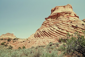
      We first set out from Paw Hole here we were treated with seeing some beautiful rock formations with precice linear designs and textures in all sorts of strange shapes and sizes.
Most of these were tan, gold or redish brown in color, and some had unusual linear textures of darker colored rock running through them.  This is just a short walk north of the Paw Hole Parking Area.
There were some very unusual Teepees with some real crazy texture way up the ridge north of here that we saw on our way back.
We traveled north from Paw Hole on a flat sandy area just east of the ridge on the way out and we traveled along the top of the ridge or as close as we could on the way back. Walking north we crossed a large area of more sand that with full packs was quite draining, after several miles we came to another area of exposed rock and more unusual formations. 
This area was near what on the map was called Cottonwood Springs, and I latter found out it was called the Cottonwood Teepee area. Walking around in this area was amazing.
  This area has some crazy behive and teepee shaped rocks in quite an asortment of colors, sizes, and shapes, along with some balanced rocks and some just plain bizare shaped rocks, that will spark your imagination. 
Everywhere you look you see something unusual in the geology here. Strange twisted shapes in a variety of colors and patterns.
  And along with that there is a peacefulness that comes with this remote and secluded area.  This are for me was more interesting more deversified and just a larger area than the Paw Hole area, but of course it's a bit more difficult to get to.  Just a longer drive in some deep sand. 
As you can see there is some strange shapes and unusual color in the rocks at this place, we had it all to ourselves when I was there.
Being able to stay overnight out in this remote destination was quite a treat. At night there was no visible human made light sources and with the dry air the star viewing was amazing.
Here is a hiking map that might be of use if you are going to Go out there and explore.  remember there really are no trails, so you just have to use a map and keep track of where you have gone and how to get back.
The Lone Tree is an undeveloped access point that provides entry to Coyote Buttes South. There is limited parking available. It is not signed. Please park in existing disturbed areas only.
     From Page, AZ, drive west on Highway 89 for 34 miles (55 kilometers). Drive past the BLM Contact Station and the road to the White House trailhead. Turn left onto House Rock Valley Road. This road is compacted dirt. Drive 16.0 miles (25.75 kilometers) down this road. Turn left (east) on a narrow dirt track and drive 0.25 miles (0.4 kilometers) and park near a lone tree next to a small reservoir.
     From Kanab, UT, drive east on Highway 89 for 38 miles (61 kilometers). Turn right onto House Rock Valley Road. This road is compacted dirt. Drive 16.0 miles (25.75 kilometers) down this road. Turn left (east) on a narrow dirt track and drive 0.25 miles (0.4 kilometers) and park near a lone tree next to a small reservoir.

For permits and more information here is the link to the BLM site that has all you need including how to obtain permits.
http://www.blm.gov/az/st/en/arolrsmain/paria/coyote_buttes.html

Here is the Link to the post on the Coyote Buttes North Section and The Wave. 
http://azjonesoutdoor.blogspot.com/2010/07/coyote-buttes-north-section.html

Cottonwood Wash Narrows, Grand Staircase Escalante-National Monument, Utah

Grand Staircase Escalante-National Monument is a huge (1.9 million acres) and vast undeveloped and wild area in southern Utah and it has very few roads.  In the western part of the national monument is a dirt road that runs north to south called Cottonwood Wash Road. It is a rugged dirt road that is impassable in wet conditions and it sees light traffic. This road runs along the "Cockscomb" also known as the East Kaibab Monocline. This is a fold in the rock layers tilting them up at 45 degree angles in spots and forming a long ridge of strange rock formations due to the differential erosion of these layers of rock. 
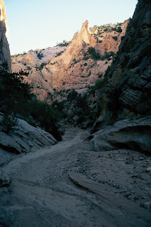
Along Cottonwood Wash Road is a short but sweet canyon hike that passes through the narrows of Cottonwood Wash.  It is a very strange narrow canyon where a wash cuts into and through a large Navajo Sandstone ridge instead of just running along it and it comes out on the same side it entered. 
   This canyon part of the hike is really only about a mile and a half, but it is an interesting mile and a half.  There is a bridge on Cottonwood Wash Road at the starting point of the north end of the hike.  From there you scramble down into the drainage west of the road and head downstream.  Almost immediately you enter in between some large rocks and are in a narrow canyon between two large cliffs.  Right at this point you will see a canyon coming in from your right or north called Butler Valley Draw. 
You can go up Bultler Valley Draw and there are about 200 yards of narrow canyon to see, and then return back down the way you came back into Cottonwood Wash.  From there head south and you will be walking along a wash bottom between some large cliffs for about a mile and a half as it winds it's was in a generally southward direction.  Early on the canyon will get pretty narrow and tight with tall cliff closing in on both sides.  The last time I was there there was an old log jambed in between the two cliffs at one spot. 
For me this is the most interesting part of the hike due to the cliff walls and rocks that are polished and smoothed from years of flash floods being forced through this small narrow slot.
The narrows will open up a little way farther downstream and you will be walking on a sandy wash bottom between two very large cliffs that I estimate could be 200 feet high or more in places.  Along this section there are a few interesting short side canyons with towering cliffs that dead end into the bottom of what appear to be dry waterfalls.  Note the backpack I left on the ground to give some perspective as to the size of the cliffs.
At one point you will hit a place where a landslide has blocked the wash but it is easy to scramble over.  There are some places where the canyon opens up and the walls are not as dramatic but even that stretch has som beauty because you can then see the unusual rock formations on the top of the Navajo Sandstone cliffs that have been sculptured over time.

 After about only a mile and a half the canyon will take an abrupt left turn and emerge out from the narrows into a wide valley.  The road will be right there and you just hike north about a mile along the road to get to your car.  The walk along the road is scenic as well with some interesting geology to see.  The whole hike can take less than 2 hours and some people do it in less.  Overall it is pretty short and mostly easy and could be a good hike for a family with kids.  And it is well worth the effort considering the beauty and the interesting geology. 
To get there you take Cottonwood Wash Road about 25.5 miles north from Highway 89 or if coming down from the north it is about 12 miles south on Cottonwood Wash Road past Kodacrome Basin.  Elevation is at 5600 feet.  Note that Cottonwood Wash Road is impassable in wet weather, so get a good weather report so you don't get your car stuck in the mud in this remote area.  Carry plenty of water and food in your car. 


Here is a link to another adventure that can be found along Cottonwood Wash Road.
http://azjonesoutdoor.blogspot.com/2010/10/yellow-rock-and-hackberry-canyon-utah.html