.jpg)
One of the most fantastic places to see sandstone formations is called Coyote Buttes. This area is located along the Arizona Utah border between Page Arizona and Kanab Utah. The first time I saw it was by accident. I was intending to backpack through a long slot canyon called Buckskin Gulch. However the weather forecast had a chance of rain (dangerous for slot canyons).

So I just started off out into the desert to camp away from the slot. What I found was a fantasy land of rock of all colors and shapes. Latter I found out that it is a permit only and day use only area.
.jpg)
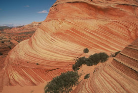
But what a treat I found as I walked farther and farther into a dream world of colorful swirling rocks. With patterns and shapes I could never have dreamed of.
.jpg) Nothing could prepare me for what I found as I went farther and farther into this crazy fantasy land of stone.
Nothing could prepare me for what I found as I went farther and farther into this crazy fantasy land of stone. 
Giant beehive or tee pee shaped buttes with stripes of all colors, Swirls and patterns and stripes in rock like I had never seen. Words can't describe this place. Hopefully the photos can show you just a hint of how amazing this is. But really they of course will fall short of showing you the context and feeling of this epic stone landscape.

Back then I didn't have digital cameras and it was so fantastic I ran out of film. But it was some of the best rolls of film I ever shot.
And I was glad that I had to change my plans due to the weather. This place is very photogenic and is a destination for photographers from around the world. And photos of this area are often found in magazines like Arizona Highways.
Anyway here is how you get there the right way. To get to the trail head you take Highway 89. The turn-off is located on the south (right side coming from Kanab) side of the road. Its between mile markers 25 and 26, at a curve in the road, at the end of a guard rail. Turn at the unmarked dirt road. This is House Rock Road. You take this dirt road south for about 8.3 miles to the Wirepass trailhead. This is also the trail head for the Wirepass entrance to Buckskin Gulch.
The trail is in a wash for the first .6 miles and then there is a marked right turn out of the wash. At the top of the first hill is the Coyote Buttes trail register, then the path follows an old sandy jeep track over a plateau and down to another dry wash. Beyond here it is less sand and more rock and the trail is harder to see. generally you head south. The route is across the wash and up the far side to the top of a small ridge, where you keep left left. Over the ridge, the land opens out to reveal a large area of sand and slickrock, with a long, large ridge to the right (the north part of Coyote Buttes), with an area of rock domes (beehives and tee pees) below. About 2 miles in front of you is the real destination at the base of a large white cliff with a vertical crack in the middle.
Right below this crack is where the best formations are (the wave). While all the rest is beautiful and impressive the wave has unique color and the consistent texture and conformity to the layers makes it special and photogenic.
It takes between one and two hours, and the hike is relatively easy, without much elevation change.
But the whole area is worth looking at and there are some arches and dinosaur tracks and just south of the Wave area is a place many call the Wave Two so spend the whole day exploring the area.
Here is a map of the hike that I made up to help get you there.
Permits: Entry to North or South Coyote Buttes costs $7 or $5 per person respectively, with a limit of 20 people for each region and no more than 6 in a single group. Half these are bookable up to 4 months in advance, by writing to the BLM in Kanab or applying via their website (https://www.blm.gov/az/paria/index.cfm, sometimes inaccessible), while the other half are available by applying in person to the BLM office at the Paria River (located south of Highway 89 between mile post 21 and 22, between Kanab and Page, Arizona), before 9 am on the day prior to the intended visit (the office opens at 8.30 am). At 9 am, if more than ten people are waiting, a lottery system is used to select the chosen few. All successful applicants receive a copy of the access regulations and, for North Coyote Buttes, a topographic map to help identify the route to the Wave, which is not well marked on the ground. There is high demand for the advance permits and all may be taken many months before the date of travel. A permit is also required for dogs - another $5. No overnight camping is permitted anywhere in the area.
Coyote Buttes Special Permit Offices
Arizona Strip Field Office: 345 East Riverside Drive St. George, Utah 84790 435.688.3200
Kanab Office: 318 N 100 E Kanab, Utah 84741 435.644.4600.
There is also a south section of Coyote Buttes and I will deal with that on a latter post.
To see more information on Buckskin Gulch, The Paria River Canyon that are in this area see these posts http://arizjones.blogspot.com/2010/09/exploring-buckskin-gulch-and-paria.html
And this one too http://arizjones.blogspot.com/2010/11/paria-river-canyon.html


No comments:
Post a Comment