
 Here is another great Eastern Sierra backpack trip. This one starts at a large lake called Lake Sabrina at 9132 foot elevation. I like this trip because the starting point is so high that there is not very much climbing to get to the good stuff. This trip heads into a lake basin called The Sabrina Basin in the John Muir Wilderness of the Inyo National Forest in California.
When I did this trip it was years ago. So things may have changed a little. When I did this the trail head parking was near the end of Lake Sabrina Road at an intersection with a westbound road that leads to North Lake. You start the hike by walking south up the paved road for about a half mile where you will find a signed trailhead. The trail traverses along open exposed slopes on the east side of Lake Sabrina. Here is a picture of my three female companions and the view as you start out along this ridge.
 About 1.3 miles from the road there is a trail junction with an east bound trail that leads to George Lake up on Table Mountain. You continue right or south at this junction. You will soon pass the small outlet creek for George Lake and then the trail starts to climb some switch backs. After the switch backs you arrive at Blue Lake at around 10400 foot elevation. This lake is beautiful and if this were the only lake on the trip it would still be worth the short trip.
  There are great views south across the lake of some dramatic peaks along the Sierra Crest, with a prominent pointed bare spire in the foreground that is close to 12,500 feet tall and Thompson Ridge with Mount Thompson at over 13,400 foot height behind in the back ground. This lake is only a little over 2.5 miles from the road so many day hikers can make this their destination.
 The trail then crosses the outlet creek of Blue Lake and then heads along the west shore of the lake. After a short way you come to a trail junction. If you head straight it will take you to Donkey Lake and the Baboon Lakes, a worth while side trip if you have the time. I did this on the way back.
  This is what it looks like up there at one of the lakes. And there is a lot of great stuff to explore using these lakes as a base camp you could go up to Sunset Lake and get a view of the Thompsom Glacier. But our trip takes the right fork and heads west at this junction. After about a mile and a quarter from this trail junction you will get to the largest of the Emerald Lakes about four miles from the road. You pass this lake and continue southwest up over a small rise to Dingleberry Lake at about 10490 foot elevation. You pass this lake along it's east shore and continue up the drainage. Less than a half mile past Dingleberry Lake and about five miles from the road there is a trail junction. If you head south or take the right fork it will take you to beautiful and dramatic Midnight Lake. Midnight Lake is at close to 11,000 foot elevation and is in a bowl surrounded by steep rocky cliffs and ridges and dramatic peaks.
 I camped here and loved the beautiful play of light off the peaks. I believe that the tall peak reflected in this photo is Mount Darwin at 13,831 feet tall.
  If you take the left fork of the trail junction below Midnight Lake it takes you to Topsy Turvy Lake where there are some great campsites with fantastic views. If you continue on past Topsey Turvy Lake you will soon reach Hungry Packer Lake at 11,070 foot elevation about 6.3 miles from the road. This lake has a dramatic spire called Picture Peak rising up just south of it making for a beautiful scene.
  From here it is a short walk west over to Moonlight Lake were the views across the lake to the Jagged Sierra Crest are fantastic.
  These photos were taken at the outlet of Moonlight Lake and fit together as a panorama. The prominent Peak in the fore ground is Picture Peak with Mount Hackel in the right background and Mount Powell and the Clyde Spires to the Left.
  Here is a pieced together panorama of the view from this same location as is the one at the start of the post.
 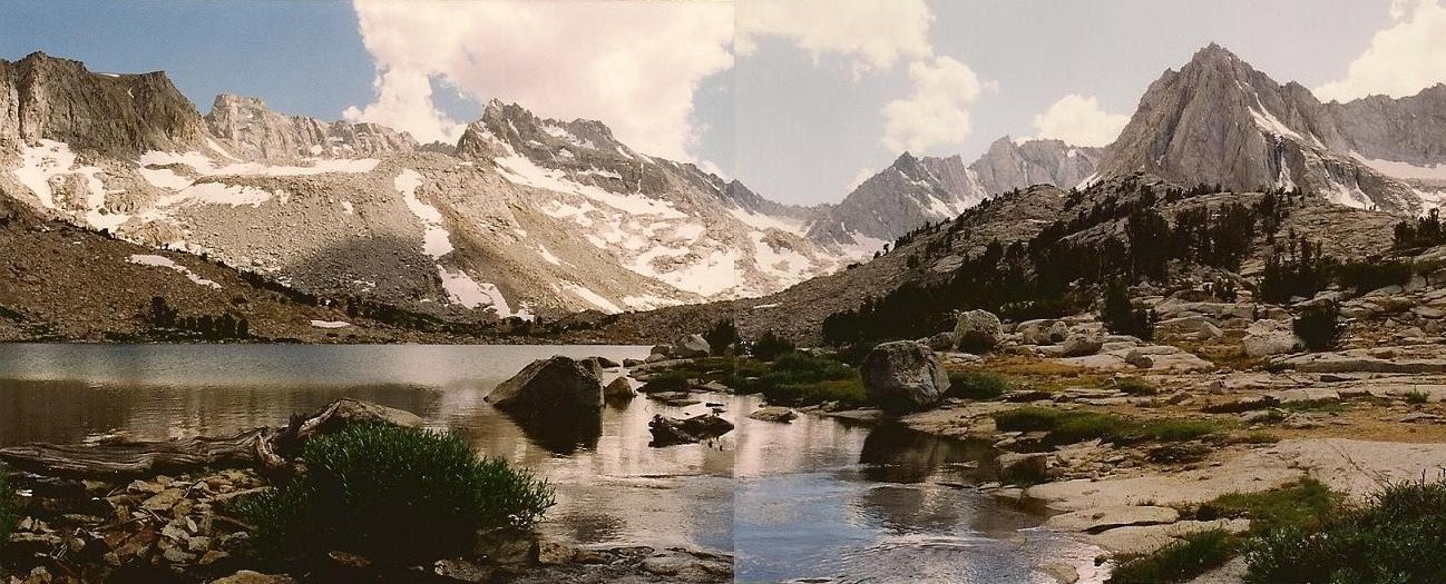 From here you can continue up the valley to the source of the Middle Fork of Bishop Creek to Echo Lake. If you are really a veteran and experienced back country traveler you could cross the Sierra Crest via this trail less route over Echo Pass and end up in Kings Canyon National Park in the Evolution region. Me I just enjoyed the short walks between the fantastic lakes in this basin and then headed back the way I came.
 By the way all these lakes have abundant trout if that's your thing. Like all Eastern Sierra trips in wilderness areas permits are required, so plan in advance.
 If you want a good map with picture interface this site is great and his photos are real fine http://doors.stanford.edu/~sr/sabrina-2006/map.html
AZ
ReplyDeleteThank you for this! Just an exquisite trip to take in my mind today :} All the best to you and your family in the new Year.
Chuck