
Around the first week of September of 2007 I went to the Mammoth Lakes area of the Easter Sierra Nevada Mountains of California. We stayed for more than a week with my wife's brother Todd. During that time the "boys" Todd, Colin (Todds nephew) and I decided to go on a backpack trip into the back country. I had planned it in advance and obtained all the permits. In describing this trip for you the elevations and distances will be indicated like this (8100 – 1.3). The elevation first with distance from trail head in miles second. Latter in the trip from Cecile Lake on (the half way point) the distance will be the distance to the ending trail head as we return, or a countdown. Some of these descriptions are from Starr’s Guide to High Sierra and Hiker’s Guide to California. This trip was in the heart of the pristine back country of the Ansel Adams Wilderness and ranged from dense forest to above tree line. We passed several lakes and some waterfalls. It was up to us to decide where we would camp. It was a loop tip and we entered at one location and exited at another. Trail heads are accessed by a shuttle bus system. This trip I tailored from different longer trip descriptions to be a short and easier trip with the biggest scenic payoff possible.
We started off at Agnew Meadows, (8300 -0.0) and headed north descending into the canyon of the Middle Fork of the San Joaquin River. We soon came to a junction with the San Joaquin River Trail at (8100 – 1.3). At this point we were in a nice dense forest.
We followed that trail heading north until we reached the junction with the Shadow Creek Trail (8100 – 2.6).
 We followed this trail heading north until we reached the junction with the Shadow Creek Trail (8100 – 2.6). We then took the Shadow Creek Trail which fords the infant San Joaquin River and climbs to the immediate right of Shadow Creek Falls. This was a nice site but the trail was steep along the falls. The trail passes to the right of the falls
 After passing a narrow rocky gap we reached the lower end of Shadow Lake (8750 – 3.3). This spot has beautiful views up the lake to Ritter and Banner Peaks.
 The trail skirts the north shore of this lake to the upper end of Shadow Lake (8750 – 4). We continued up Shadow Creek Trail passing several meadows with fine views of the Minarets and climbed up some short switch backs until we reached Lake Ediza (9300 – 6.2). Lake Ediza is located in a spectacular location at the headwaters of Shadow Creek set in the crown of Ritter and Banner Peaks and the Minarets.
 Lake Ediza is described in the Starr's Guide as one of the brightest gems in the Sierra with views of Ritter and Banner the highest peaks north of Mount Abbot and one of the most noble mountain groups in the entire Sierra range. And we couldn't believe how beautiful it was. I felt that it surpassed any descriptions.
 One of the guide books said because of the great scenery a stay overnight in this lake basin would be a memorable one. So this is where we camped. We got there with time to spare. So we set up camp and then took a side trip up to the base of Banner and Ritter peaks and still had time to get back to camp before sunset.
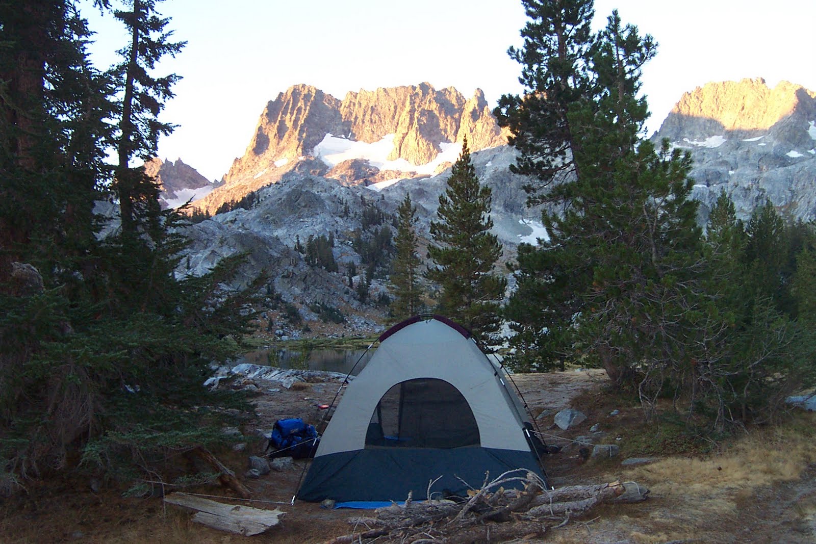 The next morning we left Lake Ediza and travel south along the east side of Iceberg Lakes outlet stream on an un-maintained trail to Iceberg Lakes (10,100 – 7.7) a wild setting at the very foot of the Minarets. This was pretty fantastic. It's a small lake in the shadows of the surrounding mountains. We then traveled south on the east side of this lake.
Our path then traveled steeply up and gained 400 feet of elevation to meet the creek draining Cecile Lake and then a last scramble up a steep pitch to reach Cecile Lake (10,300 – 8.2). This part was across boulder fields and there really is no trail.
 This last distance measurement is a guess because no guide book has the distance listed because its not really a listed trail, but I can see on the maps it is a short distance from Iceberg Lake and is probably less than I guessed. Cecile Lake is described as the highest body of water on the east slopes of the Ritter range, wedged between the dark wall of the Minarets and the black ramparts of Volcanic Ridge, this could easily be a scene from another planet. The other guide book describes this as boulder littered shores with no campsites. This area again was just rock hopping across boulder fields with no real trail.
 At this point from now on we were heading back down the Minaret Creek drainage and from here on all distances will in my description be a count down to the final destination. We boulder hopped around the east shore of Cecile Lake to the southern end and climbed a low, glacially smooth hill. At this point it was tough to find the rout down. Some were too step. From here we descend a talus covered slope with lots of loose rock with a creek draining into Minaret Lake. We followed the creek down to Minaret Lake (10,000 – 7.0). This lake with the impressive spire of Clyde Minaret to the west is an excellent choice for an overnight stay. I would highly suggest this option. So you can spent some time at this fantastic lake. But we just kept going.
 From Minaret Lake the trail skirts the north shore of this lake and soon drops through sparce forest along meadow lined Minaret creek. 1.5 miles below the lake we reached a northbound trail junction that leads to and abandoned mine. The trail from here follows an abandoned access road for the mine and soon passes a series of cascades along Minaret Creek. This is a pretty cool spot but my camera batteries died so I have no photo
After this we reached a trail junction with the John Muir Trail just north of Johnston Meadow and Johnston Lake (8150 – 3). We bore right at that junction and soon crossed over to Minaret Creek’s south bank and soon came to another trail junction of the westbound trail to Beck and Holcomb lakes where we stayed left. Within another mile we reached another trail junction where we took the middle fork. After another .25 miles at another junction we bore left and came to a foot bridge that crosses the Middle Fork of the San Joaquin River (7500 – 1). Once we crossed the bridge we reached a southbound trail that leads to Devils Post Pile. We instead turn left and head north to the Devils Post Pile Camp Ground (7600 – 0.0) and our final destination where we could catch a shuttle back. But instead my wife and child met us here and we played along the river and had a picnic.
The total distance of this tip was only around 16 miles. The forest service people said it should be no problem to do the link between Lake Ediza to Minaret Lake even though it was on un-maintained trail. And they were right. There was just some minor route finding and scrambling but it is above tree line with no real way to get lost. It is described in the Hiker’s Guide to California as part of a 23 mile loop. With the high altitude at night it can get very cold. In fact I have encountered snow in the Sierras at the end of August before. This longer trip in The Hiker's Guide sounds good to me (it’s over 100 here in AZ as I write this).
The photos I have seen of Minaret Lake on the Web site for Devils Post Pile National Monument are beautiful. But it even better in person. Other photos I have seen of Banner and Ritter Peaks and the Minarets are impressive. But photos can't give you the scale. I believe this was one of the most impressive scenic trips I have or will ever take. Even though it was a short trip it was a great one.
To get a reservation for the permit for this trip you tell the Forest Service you are going to start from Agnew Meadows (Shadow Creek Trail) and come back Minaret Trail to Devils Post Pile. You can do two to three days. But it's short enough if your time is limited to do just a one night stay.
We were able to pick up our permit at the Mammoth Lakes ranger station one to two days before our trip, because we made reservations well in advance. We were required to have bear canisters for our food. We rented these. They are hard plastic canisters that are bear resistant. We did not see ant bears, but did see deer.
Thanks much for the great pics & TR. Real pleasure. My dad took me on almost an identical trek when I was 8 yrs old -- 1958. Hey, talk about solitude, we saw no one back then. Fishing was fantastic at Iceberg -- Cecile was then called Upper Iceberg. You're gonna have to come back out and visit the beautiful lakes to the north -- Garnet, 1000 Island, more. Trek over North Glacier Pass to the beginnings of the N. Fork of the San Joaquin. So fun. Hey, you did a great job describing your trek for anyone who might want to follow that awesome route. Thanks Again, Jim J;O)
ReplyDelete